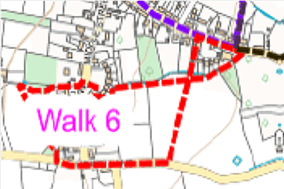
Map showing the route of the walk as described below
Route 6 from Village Hall start and return (about one hour)
Facing north with back to Village Hall, walk left along Long Street to path shortly after the turning to ‘The Paddocks’.
Follow WN19/18 left (south) between houses, over footbridge and through gate.
After approximately 6m turn right (west) onto WN19/21.
Walk across field, through gate in field boundary, straight ahead to another gate in field boundary.
Before stile turn 90° to right (west) to meet WN19/22.
Turn right to stile onto March Lane.
Cross March Lane and over stile, take path WN19/25 west.
Over a stile into woodland, straight ahead 10 m to fenced paddock.
Over stile and walk along fence line on right to metal gate on right.
Turn left (south east), on WN19/24 (almost back on yourself) and diagonally cross paddock towards the far left corner, to stile.
Through woodland, over stile by red telephone box to emerge on Hearn Lane.
Turn left.
Cross turning to March Lane, keep on Hearn Lane, past first path to left (WN19/22) to large wooden gate on left, WN19/19.
Cross field diagonally (north east).
At far boundary turn right onto WN19/20, through gate in corner of field, follow path through small wood to second gate and finally gate onto Long Street.
Village Hall is immediately on left.
The interactive Rights of Way map, not only maps all footpaths and bridleways and restricted byways, but walkers can report where they find faults with stiles etc. and cross cropping of paths.
The Countryside Code helps give balance with regard to the relationship of public rights over private land and encourages responsible use of the routes.
Funded by Somerset Community Grant & donation from The Newt