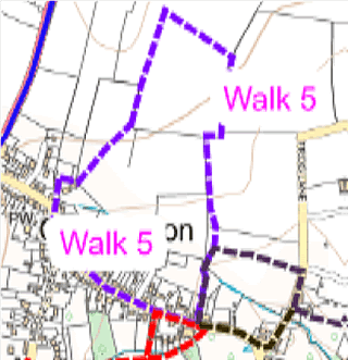
Map showing the route of the walk as described below
Route 5 from Village Hall start and return (about one hour)
Facing north with back to Village Hall walk left along Long Street to T junction.
Bear right to bend and walk straight ahead along short track WN19/16.
Turn right on track to stile straight ahead (ignore stile to left) and onto WN19/10.
Walk diagonally (north east) across field to stile in field boundary.
Bear left (north) to other side of hedge and walk along WN19/9 (north).
Before field boundary ahead turn right (south east) to join WN19/5 to meet WN19/4 running north to south, just before field boundary.
Turn right (south) onto WN19/4 to corner of field.
Turn right (west) onto WN19/11.
After a short distance, turn left (south) over small bridge onto WN19/12 over stile ahead at field boundary.
Follow WN19/13 straight ahead (south), emerging onto Long Street between houses and opposite Galhampton Village Hall.
The interactive Rights of Way map, not only maps all footpaths and bridleways and restricted byways, but walkers can report where they find faults with stiles etc. and cross cropping of paths.
The Countryside Code helps give balance with regard to the relationship of public rights over private land and encourages responsible use of the routes.
Funded by Somerset Community Grant & donation from The Newt